
Planning Information
PLANNING

Roles & Resources
Planning Roles and Responsibilities
The fundamental objective of UDOT’s Planning Division is to help the department identify areas of future transportation need and to address that need in a way that considers all users, including our transportation planning partners. We strive to help the department build the right project, in the right place, at the right time. We work in all modes of transportation, including walking, biking, and public transportation and consider it our responsibility to plan for a comprehensive transportation network that is safe, efficient, and incorporates all modes. One of the Planning Division’s tasks is to implement Utah’s Transportation Vision.Central Planning Resources
Planning Director – Andrea Olson, andreaolson@utah.govPlanning Manager – Angelo Papastamos, apapastamos@utah.gov
Planning Manager – Natalia Brown nataliabrown@utah.gov
Air Quality Planning Manager – Vacant
Long Range Planning Manager – Vacant
Urban Planning Manager – Jordan Backman jbackman@utah.gov
Region Planning Resources
Region 1 Planning Manager – Ryan Halverson, rhalverson@utah.govRegion 2 Planning Manager – Geoff Dupaix, gdupaix@utah.gov
Region 3 Planning Manager – Jeff Lewis, jefflewis@utah.gov
Region 4 Planning Manager – Chris Hall, cdhall@utah.gov
TravelWise
Travelwise

While Utah continues to experience unprecedented growth, that growth comes with more than a few growing pains and challenges. To address some of the transportation difficulties, UDOT developed TravelWise – rethink your trip. Put simply, TravelWise – rethink your trip is a set of actions that encourage Utahns to use alternatives to driving alone. By asking individuals, businesses, communities and organizations to TravelWise, we can reduce energy consumption, optimize mobility and improve air quality, ultimately improving the quality of life in Utah. More information about this program, including how to get involved, can be found at the TravelWise Website.
Walking & Biking - Active Transportation
Walking & Biking – Active Transportation
Active Transportation refers to human-powered travel, such as walking and biking, and personal electric-assisted travel (i.e. e-bikes, scooters, skateboards, wheelchairs, etc.).Quick Links:
Partner Resources:
Below, you will find links to local agencies, nonprofits, advocacy groups, and other organizations that provide information on cycling and walking.Government Partners:
Nonprofits/Advocacy:
Trail Organizations:
Community Involvement/Groups:
Committees:
Have a question? Contact Angelo Papastamos, Active Transportation Manager, apapastamos@utah.govFreight and Rail Planning
Freight and Rail Planning
Freight knows no boundaries. It moves nationally and internationally, involving countries, states, regions, counties, and municipalities. International and national freight are vital to Utah’s economy. Freight transportation affects consumers’ purchase costs and employment opportunities. Utah’s ability to efficiently handle freight impacts the state’s economic competitiveness.
Long Range Transportation Plan 2023-2050 & Long Range Planning Resources
Rural Area Plan
Every four years, the Utah Department of Transportation (UDOT) updates its Statewide Rural Long-Range Transportation Plan (LRP): to “Keep Utah Moving” now and into the future. This plan forecasts transportation needs over the next approximately 30 years and identifies a list of multi-modal projects meant to address those needs. This planning helps to strengthen Utah’s economy and enhances quality of life for Utahns.UDOT Long-Range Transportation Plan (LRP) 2023-2050
Urban Area Plans
Transportation needs for urban areas of the states are planned by the Metropolitan Planning Organizations (MPO) and transit agencies within Utah. The following agencies update their long range regional transportation plans and strategic plans at various intervals and they address urban long range transportation needs. The planning efforts and related documents for both rural and urban parts of the state are coordinated and result in the development of Utah’s Unified Transportation Plan Utah is among the fastest growing states in the country. Utah’s transportation agencies and local communities work together to ensure superior quality of life that includes good air quality, a vibrant economy, and affordable transportation choices for all Utahns.Solutions Development
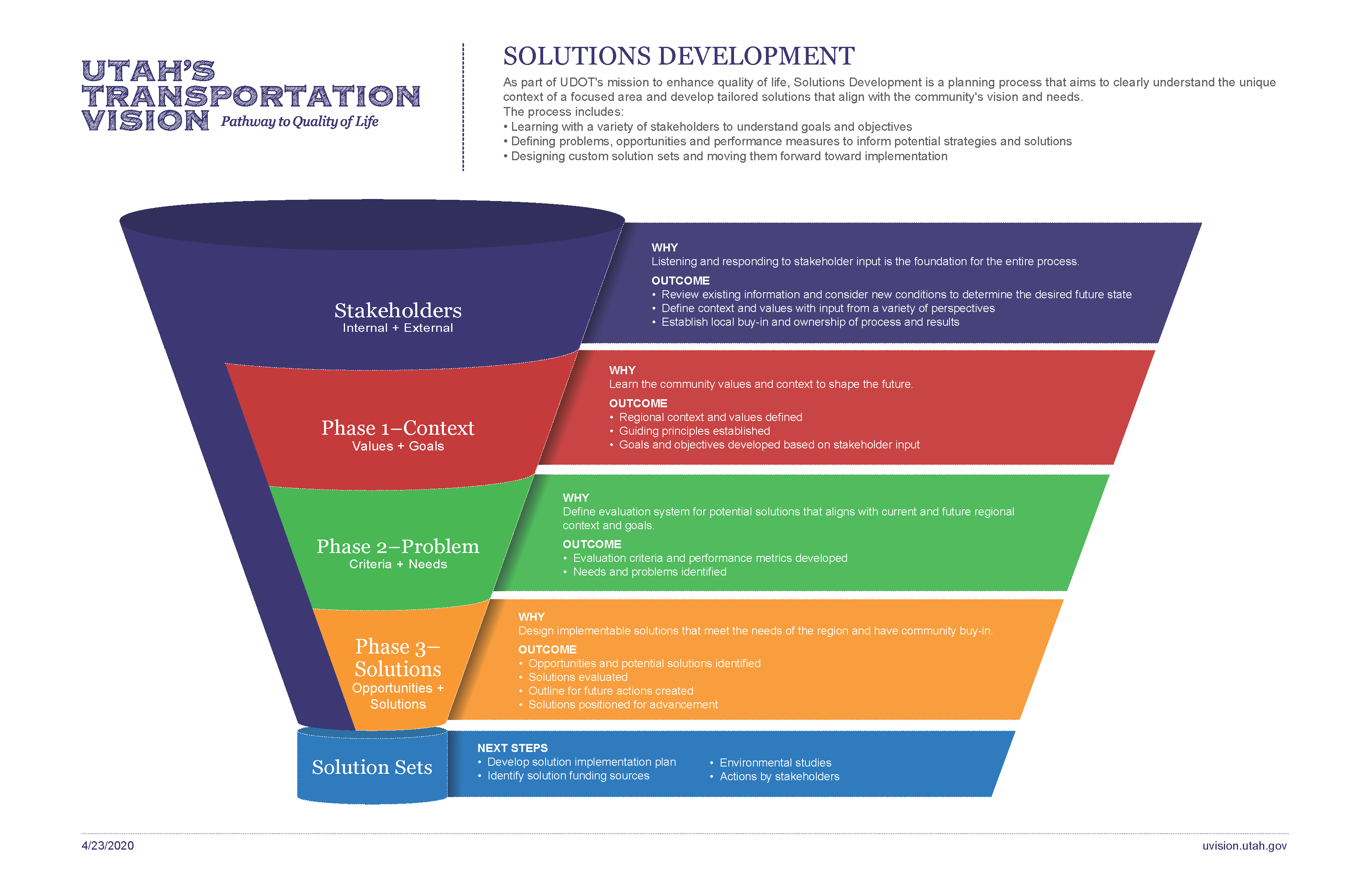
Solutions Development
Transportation planning helps to identify important transportation problems and possible solutions. Transportation planning identifies what services transportation customers, including citizens and business, need and balances those needs with competing demands to form a common vision and a plan that is financially feasible.Solutions Development is an innovative planning process being developed by UDOT that seeks to capture the unique context of an area or corridor and develop a set of solutions to meet its transportation needs. Solution sets could include things such as roadway improvements for cars, transit and/or active transportation; travel demand management; ITS improvements; land use changes (to be implemented by local government partners); and so forth. The Solutions Development process will also integrate with the work of other UDOT divisions, such as Environmental, Operations, and Performance Management. Integrating with these other areas helps ensure holistic solutions that match the area’s unique context and needs.
The Solutions Development process is an important component to implementing Utah’s Transportation Vision
Current Solutions Development projects include:
- SR-224 Kimball Junction (Region 2)
- Northeast Tooele County (Region 2)
- North Lake Shore (Region 3)
Technical Planning Assistance
Technical Planning Assistance
UDOT offers funding for technical planning assistance to local governments in Utah, especially to those that are experiencing rapid growth and/or lack sufficient resources to carry out planning projects on their own. These funds are awarded on a competitive basis. Eligible project types include:- Community Visioning Projects
- Transportation Master Plans
- Active Transportation/Multimodal Plans
- Corridor Plans/Solutions Development Processes
- General Plans
- Zoning Code Updates
- Small Area Land Use/Transportation Plans
Travel Demand Modeling
Travel Demand Modeling
The Travel Demand Modeling group is responsible for the development and maintenance of the Utah Statewide Travel Demand Model (USTM). We also coordinate closely with the Metropolitan Planning Organizations (MPOs) and other planning organizations across the state in the development and maintenance of other travel demand models used across the state for transportation planning. Our work includes:- Developing future population, household and employment distributions for UDOT planning areas in coordination with local and regional governments.
- Forecasting travel patterns, vehicle volumes, and vehicle miles traveled.
- Forecasting travel demand on highway networks as a means of assessing existing performance and evaluating the effectiveness of future planned investments.
- Natalia Brown, Travel Demand Model Program Manager, nataliabrown@utah.gov
There are five travel demand models in the state. While UDOT supports the development and ongoing maintenance of all of these tools, model ownership varies depending on geography.
Wasatch Front Travel Demand Model – Owned and maintained jointly by the Wasatch Front Regional Council (WFRC) and Mountainland Association of Governments (MAG), this model covers the most heavily populated areas of the state, including most of Utah, Salt Lake, Davis, Weber counties, as well as a portion of Box Elder County. More information about this model can be found here.
Cache County Travel Demand Model – Owned and maintained by Cache Metropolitan Planning Organization (CMPO), this model covers all of Cache County, including areas outside of the CMPO area.
Washington County Travel Demand Model – Owned and maintained by the Dixie Metropolitan Planning Organization (DMPO), the model covers all of Washington County, including areas outside of the DMPO area.
Summit/Wasatch Travel Demand Model – Owned and maintained by UDOT, MAG, and Summit County, the model covers all of Summit and Wasatch Counties.
How Can I Get a Copy of the Model?
If you would like to obtain a copy of the USTM or Summit/Wasatch Model, please contact satomlin@utah.gov To obtain a copy of any of the other models please contact the MPOs directly.
What Land Use Assumptions are Used in the Models?
Through coordination with the MPOs and technical assistance from WFRC, UDOT has developed this web map to make Traffic Analysis Zone (TAZ) level land use forecasts more easily accessible.
Managed Lanes
Managed Lanes
As Utah’s population grows, maintaining and enhancing mobility becomes more challenging. Traditionally, mobility can be improved by adding capacity to the system: building new roads and widening existing roads. This becomes more difficult and costly as we build out our communities and place increasing demands on our transportation system. An alternative path to enhanced mobility is to optimize the existing system. Potential managed lanes are operational strategies to optimize the carrying capacity of existing transportation facilities. Some examples of managed lanes include, High Occupancy Toll (HOT) Lanes, Toll Roads, Reversible lanes, Part-time Shoulder Use, etc.- Utah Managed Lane Study (24MB PDF File)
- Utah Managed Lanes Study Website
Air Quality Modeling
Air Quality Modeling
Utah Department of Environmental Quality- Air quality non-attainment areas, state implementation plans (SIP) and planning, air quality standards and plans.
- This web site provides information on FHWA’s air quality programs, including transportation conformity, air toxics, and the Congestion Mitigation and Air Quality Improvement (CMAQ) program.
- This guidance describes how to use the MOVES emissions model to estimate CO emissions from transportation projects, including roadway intersections, highways, transit projects, parking lots and intermodal terminals.
- Intersection Model: CAL3QHC/CAL3QHCR
Transportation Conformity Guidance for Quantitative Hot-spot Analyses in PM 2.5 and PM10 – Guidance (Appendices)
Transportation Conformity Regulations as of April 2012
- Transportation and Climate Division Office of Transportation and Air Quality, U.S. Environmental Protection Agency – This document includes the current transportation conformity rulemakings promulgated by EPA as of April 2012.
- The air quality provisions of the Clean Air Act as amended (42 USC Sections 7401-7671q) establish restrictions on emission reductions from transportation sources. Regulations governing transportation conformity are found in Title 40 of the Code of Federal Regulations (40 CFR Parts 51 and 93).
- The MAP-21 provides just over $2.2 billion in CMAQ funding for each year of the authorization 2013 and 2014. While project eligibility remains basically the same, the legislation places considerable emphasis on diesel engine retrofits and other efforts that underscore the priority on reducing fine particle pollution (PM 2.5).
- This web site provides guidance to state DOT’s including transportation conformity, Policy and Guidance, laws and regulations, air quality regulatory documents and rulemakings. You may also link to a comprehensive listing of EPA’s Federal Register Notices.
- This section provides access to information on EPA’s transportation conformity program. Transportation conformity is a Clean Air Act requirement that serves as a bridge to connect air quality and transportation planning activities.
- Federal Register Notice of Availability / Vol. 75 No. 243: Official Release of the MOVES2010a and EMFAC2007 Motor Vehicle Emissions Models for Transportation Conformity Hot-Spot Analyses and Availability of Modeling Guidance (December 2010).
Have a Question? Contact, Andrea Olson, andreaolson@utah.gov
Air Working Group
Air Working Group
This page contains agendas, notes, comments, definitions and links for members of the Air Working Group for the Mountain View Corridor.AWG Documents and Reports
Definitions and Comments
- Basic Definitions
- Response to Comments on the Draft EIS
- Utah Moms for Clean Air and Physicians for a Healthy Environment Comments
- Sierra Club and Utahn’s for Better Transportation Comments
AWG Meeting Minutes
Other Links, Studies and Documents
- SCAQMID Near-Road Mitigation Measures and Technologies Forum
- HWA Mobile Source Air Toxics Study
- Safe Routes to School and Traffic Pollution: Reduce Children Exposure to Unhealthy Air
- Analyzing, Documenting and Communicating the Impacts of Mobile Source Air Toxic Emissions in the NEPA Process
- Ambient Air Pollution: Hazards to Children
- Childhood Cancer Incidence Rates and Hazardous Air Pollutants in California
- Epidemiologic Evidence for Air Pollution and Childhood Cancer
- Effect of Exposure to Traffic on Lung Development: Age 10 to 18
- Provisional Assessment of Recent Studies on Health Effect of Particulate Matter Exposure
- Proximity of California Public Schools to Busy Roads
- Mountain View Corridor Record of Decision and Final Environmental Impact Statement